
Erasmus Bridge, Rotterdam: A Visitor's Guide to the Erasmusbrug
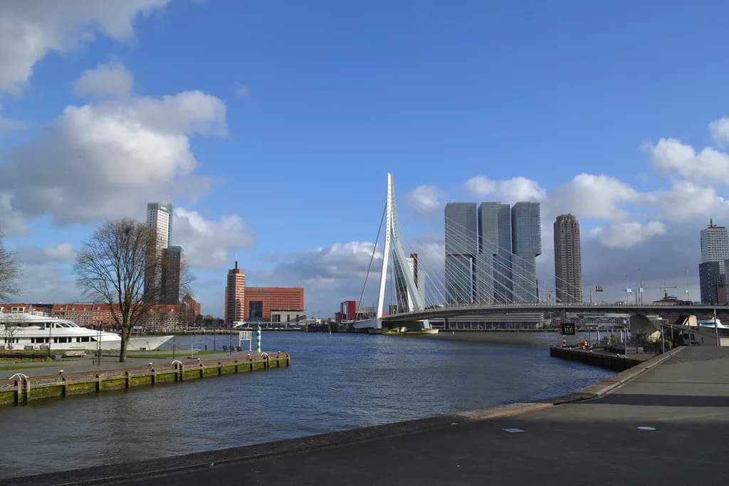
The Erasmus Bridge is Rotterdam's signature structure: a single asymmetric steel pylon rising over the Nieuwe Maas, with cables fanning down to a road deck that joins the city centre to the Kop van Zuid district. It is a bridge you cross rather than a sight you enter, so the real decision is whether you want a look from the bank or a walk over and back. This guide covers its scale and history, the Kop van Zuid connection, the viewpoints that work, and what is worth combining with it on either side.
What the Erasmus Bridge is and why it defines Rotterdam
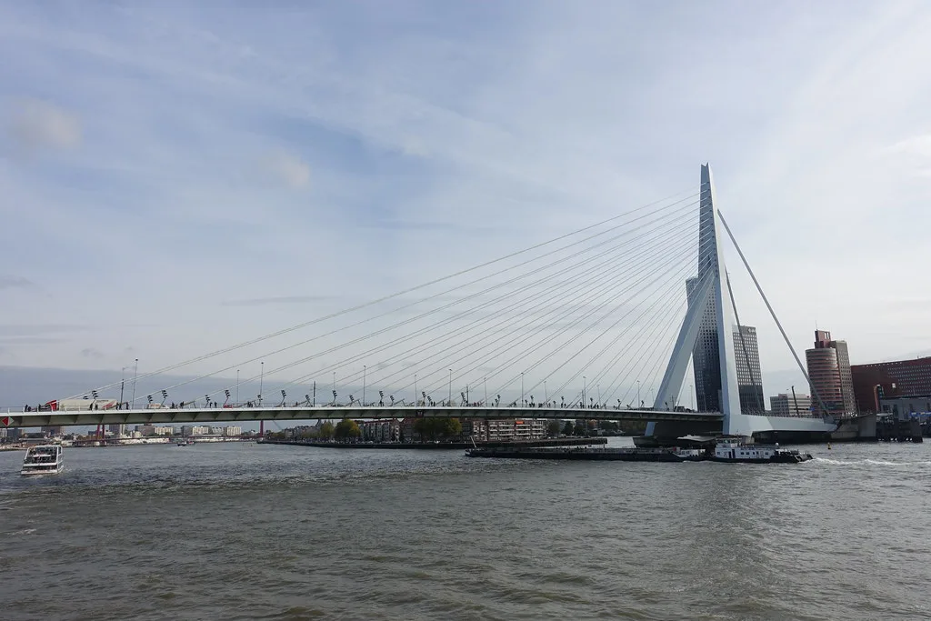
The Erasmusbrug carries traffic across the Nieuwe Maas between the northern city centre and the southern Kop van Zuid area, a district the bridge helped to open up. The project page on the UNStudio site gives the design credit to Ben van Berkel and an intentionally asymmetric form: one tall pylon, cables sweeping down at an angle, and a deck in what the studio calls sky-toned steel. That shape is why it reads as a piece of engineering sculpture rather than a piece of road furniture.
Construction began in 1986 and the bridge was completed in 1996; the project page on the UNStudio site dates its involvement with the design to 1990–1996. It takes its name from the Rotterdam humanist whose name appears across the city.
How big it is: the 802 m span and the 139 m pylon
The project page on the UNStudio site gives the total bridge length as 802 m and the pylon height as 139 m. The pylon is the part you navigate by: it is visible from much of central Rotterdam and works as an orientation point when you are walking back from the southern bank.
Treat the crossing as a proper walk rather than a few steps between two sights. At an easy pace, allow roughly fifteen to twenty minutes to get from one end to the other, and the same again back if you return on foot. Readers who only want the photograph can skip the deck entirely and stay on the bank.
Where the bridge sits: the Nieuwe Maas and the Kop van Zuid link
The bridge runs north-south over the Nieuwe Maas, landing in the centre on the north side and in Kop van Zuid on the south. The project page on the UNStudio site describes the crossing as announcing the transformation of Kop van Zuid, the old harbour district it made reachable from the centre. If you are working out where to begin, start from whichever bank fits the rest of your day, because there is little point doubling back over the river.
Crossing on foot: what to expect on the deck
The deck is exposed: wind funnels across the open water and there is little shelter until you reach the far end. Plan for the weather you actually have rather than the weather in a photograph.
The deck is a road bridge, and the reliable way to cross is as a pedestrian alongside the traffic rather than as a destination in its own right. Walk to the far end to look back towards the centre for the skyline and the pylon.
Cycling across the Erasmus Bridge
If you are cycling in Rotterdam as a way of getting around rather than as a day out, this is one of the simplest crossings of the Nieuwe Maas in the centre.
Best viewpoints and how to photograph the bridge
The classic view is from the bank rather than the deck, where you can back off far enough to fit the whole pylon and the fan of cables into one frame. From the southern end in Kop van Zuid, the angle is tighter and the pylon dominates the shot, which suits images that show scale rather than the full span.
Seeing the bridge from the water
The bridge can be seen from the water as well as the bank, giving a lower angle than the deck. Put it together with the rest of a river-level day if that suits your route rather than treating it as a separate outing.
What is on the north bank and what is on the Kop van Zuid side
On the north side you are within walking distance of the centre, which puts the rest of the city's sights on the same afternoon. Markthal Rotterdam, a covered food hall in the Laurenskwartier, is a practical place to eat after a windy crossing, and it is easy to combine with a walk back through the centre.
Kop van Zuid gives you modern architecture on the water and a different, quieter feel from the historic centre. Kunsthal Rotterdam, the Rem Koolhaas-designed exhibition building, sits on the north side of the river, so treat it as its own visit rather than a stop on the crossing. Between the two, you get a clean contrast between harbour redevelopment and the city's older streets.
When to go: daylight, evening and how busy it gets
Daylight is the safe choice: the cables and steel read clearly, the photographs are predictable, and you can see where you are walking. In the evening the bridge and skyline take on a different character, but a dark, windy deck is a less comfortable place to linger, so keep evening visits short and start from the bank you plan to end on.
Practical points: public infrastructure, weather and wind on the deck
The bridge is public road infrastructure rather than a ticketed attraction, built for the City of Rotterdam's development company according to the project page on the UNStudio site. Expect to cross as part of the street network rather than through a gate. Plan around the weather too, because wind on an exposed river crossing is the one factor that changes the experience most.
Allow more time in wind or rain, and keep hold of hats and loose items. If you are combining the bridge with a museum day, put the crossing either at the start, when you are fresh, or at the end. Conditions on the water can be brisker than in the streets behind you.
Cross the bridge or just photograph it?
Cross if you want the sense of the river and the skyline from the water, and build the walk into a route that ends in Kop van Zuid rather than doubling back. Photograph it from the bank if your time in Rotterdam is short and you would rather spend the hours in museums and streets than on an exposed deck. Either way, the pylon, not the pavement, is the thing worth your visit.
Explore more Rotterdam guides
Frequently Asked Questions
Why is the Erasmus Bridge famous?
Its single asymmetric pylon, 139 m tall, and the fan of cables over an 802 m crossing give Rotterdam an instantly recognisable silhouette. The project page on the UNStudio site describes it as announcing the transformation of Kop van Zuid, so it reads as a piece of urban planning as much as a bridge.
How long is the Erasmus Bridge and how tall is the pylon?
The total bridge length is 802 m and the pylon height is 139 m, according to the project page on the UNStudio site.